Beating the Bounds – A Story of Meliden’s Boundaries
Perhaps you have seen the Ordnance Survey map in the vestry at St. Melyd’s which shows the boundary changes in red marker pen after the townships of Ffrith and Towyn were transferred to the growing Parish of Prestatyn in 1939. Before maps became common, parishioners learned their boundaries by memorising features such as streams, hedges, roads and footpaths and if there was nothing suitable, it would be necessary to place boundary stones and make sure that everyone knew where they were—especially neighbouring churchwardens who would move boundary stones if they thought they could get away with it!
I am not sure if our predecessors ever beat the bounds—the ancient ceremony of going a-ganging. Since Norman times, some parishes armed their choirboys with sticks and walked them along the parish boundary during Rogation Week. They visited each of the markers in turn and beat them with their sticks to help them remember where they were located. In some parts of the country it was a custom to bump the boys’ heads against the various landmarks to make sure they would not forget—and in some parishes, just to make sure, the wardens beat the boys as they beat the bounds!
The Importance of Meliden’s Boundaries
The boundary was important because it governed individual rights to poor relief, entitlement to grazing rights on common land, payment of tithes and taxes, land ownership and much else. Beating the bounds of a city or town parish was achievable in a few hours but the old parish of Meliden included all of present-day Prestatyn and Nant which would have been something of a challenge because of its great size and the difficult terrain on the hillside. The custom died out after Ordnance Survey maps became available from the 1840s and for the first time, any person with enough money could buy a copy learn the parish boundaries from their armchair.
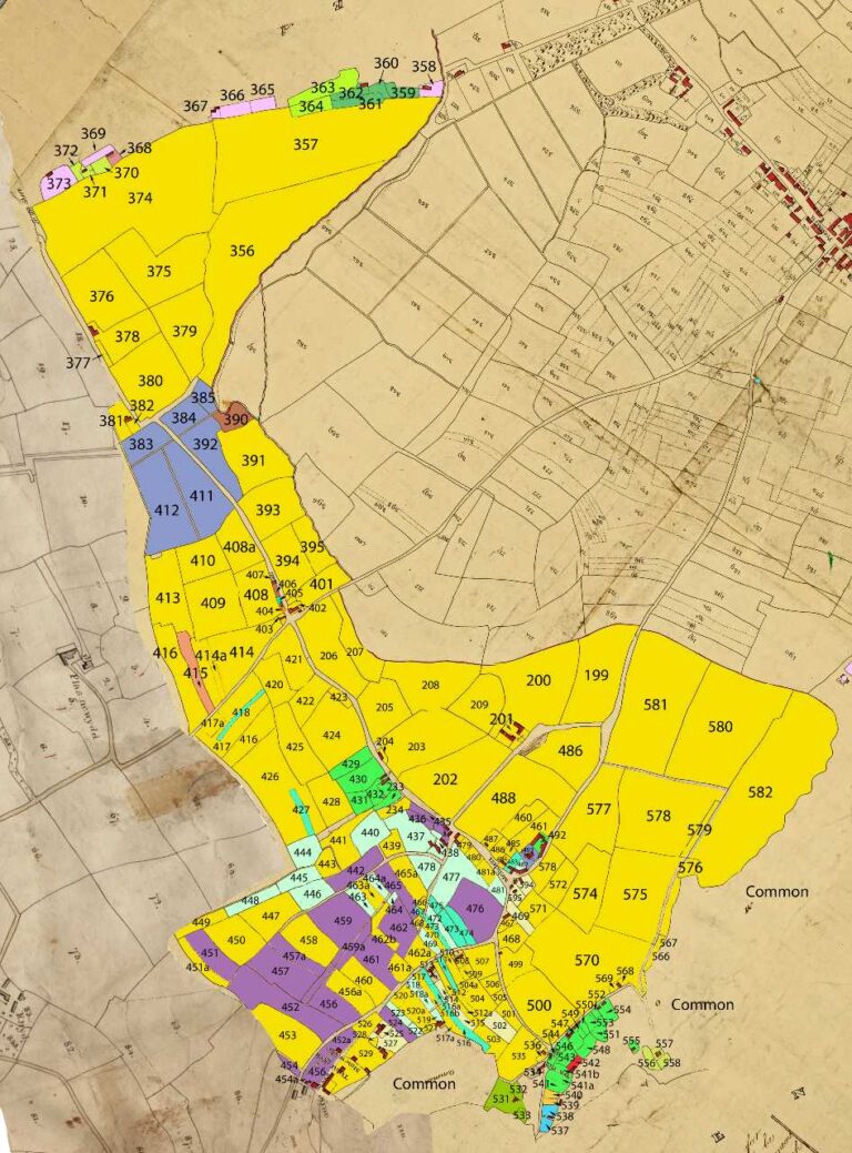
How were the boundaries chosen? To answer that question, we need to look at the tithe maps. After 1839, tithes were paid in money instead of produce because society had become less agriculturally based and the Church preferred cash anyway. Under the new regulations, a Plan of the Parish of Meliden in the County of Flint Made for the Commutation of Tithes was drawn up by Richard Godwin Dawson. [He is buried in Meliden—third grave to the right of the big Dawson tomb.] It shows almost every building, road, river and field in the parish. Each property was given a number to identify it and the map was accompanied by a detailed schedule recording who the landowner of the property was, the person renting it, the type of property, its purpose, its size and, most importantly, the amount of tithe money due to be paid.
These tithe maps were, in most cases, the first detailed maps ever made of the British countryside. Most of Meliden was owned by Lord Mostyn and the boundaries of his land created what we call now call Meliden. Prestatyn was always a different place with different landowners and only a part of the Parish of Meliden for reasons of church administration within the Diocese of St. Asaph. The Mostyn family did own some land in Prestatyn but the principal land owners were Thomas Longueville who owned much of the town and Charles Sankey who owned the Nant Estate and other parts of the town. On the Dyserth side of Meliden, Lord Mostyn’s land was bordered by the estates of Henry Clive, William Williamson and Thomas Harrison—but Meliden was his—mostly.